Posts

Showing posts with the label Places

Laponian Region in Finland: A Natural Jewel

Image
In this circumpolar region of northern Finland live the Sami, the name the Lapps give themselves. It is the largest and one of the last areas where an ancestral way of life based on transhumance is still practiced. Every summer, the Saami drive their immense herds of reindeer into the mountains in a natural landscape of extraordinary beauty. The first traces of man's presence in these lands date back to the Paleolithic period, towards the end of the last glaciation, about 10,000 years ago. They were a nomadic people whose presence was detected by the foundations of their houses and homes, who lived by hunting and gathering and whose main source of subsistence was reindeer. The present inhabitants, the Sami or Lapps, arrived in these latitudes from the east some 5,000 to 4,000 years ago. Other peoples from the south arrived at the same time but settled along the rivers and lakeshores. 

Luther Memorials in Eisleben and Wittenberg: The Birthplace of Protestantism

Image
The Wittenberg Castle Church where Luther posted his 95 Theses The small towns of Wittenberg and Eisleben have achieved universal fame, not for their wealth of monuments, but for having been the scene of one of the most important events in history: the birth of Protestantism led by Martin Luther. The houses in which Luther was born and died in Eisleben illustrate his way of life and those of his contemporaries. The houses of the reformer and his disciple Melanchthon in Wittenberg, as well as the town church and castle, have for centuries become important centers of pilgrimage. Due to the richness of its copper and silver mines, Hans Luder, the reformer's father, moved to Eisleben in 1483. On November 10 of that year, Martin Luther was born. After studying philosophy, he entered the Augustinian order in 1505. In 1510 he was assigned to Wittenberg, where he became a professor of biblical studies at the university. On October 31, 1517 he set the Reformation in motion by hanging his fa

Garamba National Park: The Home of the White Rhinoceros

Image
It sometimes happens that the popular name of a faunal species does not seem to have a logical explanation, but when the name refers to something as obvious as color and it turns out that the chromatic aspect of the species has nothing to do with the one applied to it, we reach an absurd situation. It has been said that the white rhinoceros received its name when the Europeans saw the first specimens covered in whitish slime and it has also been said that its name is actually a deformation of the terms used by the Dutch Boers: "weit" which means long or "wijt" which means wide and which in both cases are reminiscent of the English word "white". In any case, the white rhinoceros is the great faunal jewel of the Caramba National Park, created in 1938, no less, precisely to ensure its protection. 

Kilimanjaro National Park: A Blanket of Perpetual Snow in Equatorial Africa

Image
If there is a national park in Africa that can be considered the paradigm of the irresistible attraction that these places exert on the western world, it is undoubtedly Kilimanjaro, and if there is an image that represents the perfect synthesis of the natural landscape that those who want to visit the black continent dream of, that image, without a doubt, is an immense plain full of animals in freedom, on which, in the background, the immense snow-capped mass of Kilimanjaro stands out. The Kilimanjaro

Memphis and Its Necropolis and Areas of The Pyramids of Giza to Dahshur

Image
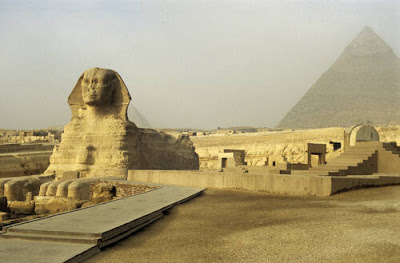
From Khartoum (Sudan), the Nile rushes successively in six waterfalls, numbered from north to south; so that the sixth is close to this city and the first at Aswan, where the Nile enters Egypt. Before the gigantic dam of Aswan was built, the Nile overflowed every year because of the torrential rains that fall in Ethiopia and fertilized the lands near the river. The Egyptian civilization flourished along the 1200 km that separate the first waterfall from the Mediterranean Sea, in two distinct areas: the upper Nile, which reached Aswan, and the lower Nile, or Nile Delta. About 5000 years ago, King Menes unified upper and lower Egypt, founded the first dynasty, and made Memphis the capital of his empire. With the first pharaoh of the third dynasty, Djoser, the period that historians call the Ancient Empire began. To this monarch belongs the step pyramid of Sakkara built by the great architect Imhotep.

Historic Center of Oporto: Portugal's Baroque City Par Excellence

Image
Its medieval streets form, as if falling into the Douro river, a dense irregular pattern, while in the most modern part of the city Porto opens up into wide avenues and squares. After playing a decisive role in the early years of independence, which was reflected in its Gothic architecture, thanks to the prosperity generated by the wine trade in the 18th century, Porto developed a Baroque architecture of great beauty. Inhabited since the 8th century B.C., it began to have some relevance as a Roman camp. Today it has become the second most important city in the country and a great commercial and economic center with a great wealth of monuments. A view of the city

Monastery and Site of The Escurial: Castilian Architecture At Its Finest

Image
In the southern foothills of the Sierra de Guadarrama, within sight of the Spanish capital but prudently removed from it, stands the mystical dream of a solitary man. Monastery and Site of The Escurial, one of many architectural relics in Spain

Old Town of Segovia and Its Aqueduct: A Millennial Beauty

Image
Name : Old Town of Segovia and Its Aqueduct (Spain) Declared International Heritage Site in: 1985 Location: It is found in the center of Spain, 85 kilometers north of Madrid The Alcázar of Segovia, one of the most splendid castles in Europe An immense Roman aqueduct from the 1st century serves as an emblem of pride, a tourist attraction, and even a heraldic shield for a city, however, deeply medieval whose rich monumental heritage reminds us that it was an important stronghold when the border between Christians and Muslims passed through the peaks of the Sierra de Guadarrama and later played an important role in the internal wars of the Castile of Isabella the Catholic and Charles I. 

Aachen Cathedral: Charlemagne's Home

Image
Name: Aachen Cathedral Location: in the center of the city of Aachen, in the German state of Nordrhein-Westfalen Charles Martel died in his favorite city, Carisiacum  (nowadays, Querzy-Sur-Oise, in the north of Paris), where his son Pepin the Short (year 751 A.D) and his grandchildren Charles (future Charlemagne) and Carloman would be later crowned. Carloman died at a young age, just before his enmity with his younger brother Charles caused a catastrophic situation for the kingdom. The death of Carloman in 771 allowed Charles (742-814) to be crowned as a lone king in 768. A fast and victorious war against the Saxons made Charles take hold of the vast majority of lands of the ancient Roman Empire in Western Europe, except for the British Islands and the Iberic Peninsula. Charles added to his own name the adjective of Magno  (in English 'Magne') and utilized Christianity as a binding agent for his empire. The Saxon nobility admitted his participation in the newborn European po

Durham Castle and Cathedral: Pioneering English Architecture

Image
Name: Durham Castle and Cathedral. Location: in northeastern England, in Durham county, near the border with Scotland. Castle and cathedral: the two great symbols of medieval Europe form in Durham a harmonious complex, accentuated by its splendid placement on a rocky spur that dominates the water of River Wear. For centuries, these buildings incarnated the spiritual and temporary power of the prince bishops who governed in the border with Scotland on behalf of the English Crown; nowadays, they represent the most notable sample of the Anglo-Norman style that England used to challenge the Romanesque one. Durham Castle and Cathedral

Historic Center of Prague: A Treasure in Central Europe

Image
Name: Historic Center of Prague (Czech Republic). Location: in the center of the country, in Central Bohemia. The remains of prehistoric settlements in Prague, which have been preserved up to these days, barely provide us any information. The first people about whom we have enough data is the Boii, a Celtic people that made this region be known as Bohiobaemun , term from which comes the word  Bohemia , the name of this European region. In the 9th century, the Slavic tribe of the Czech settled near the banks of river Moldava (currently Vltava), and they fortified a hill, at the same place where it stands the spectacular Prague Castle nowadays; soon they dominated Bohemia  and converted this into their new capital. Old Town Square, Prague

Prussian Heritage: The Brandenburg Gate

Image
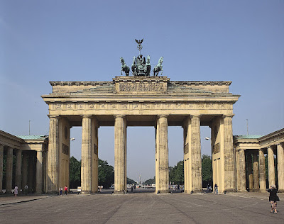
Under Frederick William II, Prussia established a reputation as a country where the arts flourished. The king acquired the services of three major architects - Friedrich Wilhelm von Erdmannsdorff, Carl Gotthard Langhans, and Carl von Gontard - and appointed the young Johann Gottfried Schadow his court sculptor. He revived the Academy of Arts ( Akademie der Künste ), which had been in existence since 1696, and in the Minister of State whom he appointed its curator, Friedrich Anton, Baron von Heinitz, he found a skillful reformer who in addition bridged the gulf between the arts and industry, since he was President of the Royal Porcelain Manufacturing Commission. In 1790, new regulations made it possible to build up a collection of models and found a school of draftsmanship for craftsmen. The royal collections were open to members of the Academy and their pupils, and methods of architectural training were updated. From 1786, the Academy held its regular exhibitions in Berlin, providing a

Kremlin and Red Square of Moscow: The Power of Architecture

Image
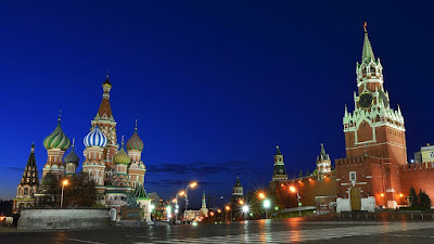
When in the 12th century, Prince Yuri Dolgorukiy founded a primitive city "made of wood" called Moscow, destroyed several times by multiple fires and rapidly rebuilt, a small stronghold had just been created. It occupied a twentieth part of the current Kremlin and in its surroundings were found the courtesan residences, as well as the artisans and merchant's ones. Some small religious buildings were also erected. In 1263, it was established the Grand Duchy of Moscow. In the middle of the 14th century, Prince Ivan Kalita walled the stronghold with solid and robust oak walls and in 1328 the capital of the Duchy was translated from Vladimir. Because of the continuous threat of invasions, in 1367 Prince Dimitri decided to raise the first stone walls. The Kremlin and the Red Square

Castles and Town Walls of King Edward I in Gwynedd

Image
Name: Castles and Town Walls of King Edward I in Gwynedd. Location: in northern Wales, on the coast. The vast plan of fortifications traced by Edward I of England to consolidate the conquest of Wales in the 13th century, the complex made up of the castles of Beaumaris and Harlech, next to the fortified villages of Caernarfon and Conwy, stands out as the best example of the military architecture of the time and one of the best works designed by his genuine servant, the Savoyard Master James of Saint George, architect of the works of Edward I in Wales. Caernarfon Castle, Caernarfon, Gwynedd in North-West Wales

The Hanseatic City of Lübeck: A Fairy-Tale City

Image
Name: Hanseatic City of Lübeck (Germany). Location: in northern Germany, in the land of Schleswig-Holstein. Lübeck, the old city of the Hanseatic League, preserves very well until this day its vast and splendid medieval zone. Among 14th-16th century residential districts, there are still boroughs full of artisans and merchants who reflect the original profile of the city which dominated the trade in Northern Europe for centuries. Holstentor (Holsten Gate) in Lübeck, Schleswig-Holstein (Germany)

The Mongol Empire: The Largest Contiguous Empire in History

Image
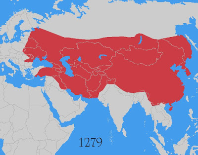
The Mongols, a semi-nomadic ethnicity dedicated to grazing and hunting, have always been considered as the "lords of the steppe". Between the 13th and 15th centuries, the Mongol tribes unified under the authority of a single leader, or Khan, and they managed to conquest the entire Asian continent, including China. At its peak, the Mongol Empire had dominated all Asian commerce, controlling a territory that went from the Great Wall of China to Persia and southern Russia, even threatening countries and regions in Europe, like Poland or Bohemia in the current Czech Republic. The Mongol Empire at its Peak under Kublai Khan's leadership

Arkansas: The Natural State

Image
It is one of the southern states of the United States of America. It has an area of around 53,179 square miles, being the 29th largest state in the country. It has a population of 3,013,835 inhabitants, ranking 33rd, and a population density of 56.4 people per square mile, low in comparison with the average density in the country. Its capital, Little Rock (198,606 inhabitants) lies in the center of the state. Official Flag of the State of Arkansas

Arizona: The Grand Canyon State

Image
State of the United States of America situated in the southwestern part of the country. It covers an area of 113,990 square miles, making it the 6th largest state in the country. Its population is 7,171,646, being Arizona the 14th most populous state and the 33rd one in terms of population density (57 people per square mile). Its capital is Phoenix. The metropolitan area of the capital contains 3/4 of the total Arizona population. The Grand Canyon, The Treasure of Arizona

Massachusetts: A Historic State in the Eastern Coast

Image
A state located in the northeastern United States. It has an area of 10,565 square miles, which makes it the 7th smallest state of the country, and a population of 6,902,000 inhabitants, making it the 15th most populous state and the 3rd with a higher density of population. The capital of the state is Boston. Due to the exiguity of its territory, physical characteristics, industrial activity, urban centers and its density of population, Massachusetts shares similar features with the states of Rhode Island and Connecticut, neighboring states. Harvard University, in Cambridge (Massachusetts)

Ohio: An Industrial State from the Midwest

Image
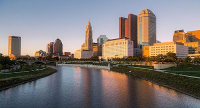
American state located in the Great Lakes region. It has an area of 44,825 square miles, being the 34th largest state by area. Ohio contains a population of 11,689,442 inhabitants what makes it the 7th most populous state. The capital of the state is Columbus, which lies on the center of the state. It is recognized nationwide by its industries, specially the motor industry as it is the second largest producer of automobiles behind Michigan.  The third part of the eastern sector belongs to the Appalachian Plateau. The old eroded surface has been occupied by numerous valleys and tributaries of the great river Mississippi or of the Lake Erie; Ohio has a very rugged topography.  Columbus, Capital of Ohio and the Scioto River