Posts

Showing posts with the label Places

Historic Center of Willemstad: A "Tropicalized" Holland

Image
In 1634, in a beautiful natural Caribbean harbor on the island of CuraƧao, the Dutch established a trading post. It soon developed into a thriving city that today presents an urban center with different historic districts, whose architecture reflects both the styles of the Netherlands and the Spanish and Portuguese colonial cities with which Willemstad carried out its commercial transactions. The historic area of Willemstad is characterized by an urban landscape consisting of four historic neighborhoods: Punda, Pietermaai, Otrobanda, and Scharloo, which are separated by a natural harbor. Although each has its own urban morphology, they all share a "tropicalized" historic Dutch architecture.  The World Heritage site consists of a central part built by the bay of Sint Anna and a part of the Caribbean Sea, the Punda neighborhood, and a large area of Otrobanda, plus two transmission areas that penetrate the neighborhoods of Pietermaai and Scharloo. The mouth of Sint Anna Bay is p

Berlin's Museum Island: One of Berlin Top Tourist Attractions

Image
Berlin's Museum Island is a complex of buildings consisting of five individual museums of remarkable artistic importance, located in the heart of the city, illustrating the evolution of modern museum design from 1824 to 1930. The Pergamon Museum ( Pergamonmuseum ), one of the 5 museums in Berlin's Museum Island The Spree Island, today known as Museum Island, began its development with the creation of a pleasure garden (Lutzgarten) in the 16th century. But its current importance began with the construction of the Altes Museum, according to the design of Karl Friedrich Schinkel in 1824-1828. In 1841 Friedrich August StĆ¼ler, court architect to Friedrich-Wilhelm IV, drew up a plan to convert the part behind the museum into "a sanctuary for the arts and sciences". The first element of this plan was the construction of the Neues Museum. This was followed in 1866 by the construction of the Nationalgalerie by Johann Heinrich Strack. Then, between 1897 and 1904, the Kaiser-Fri

Historic Center of Graz (Austria): Austrian Bastion Against Ottoman Turks

Image
With a collection of well-preserved buildings dating from different periods, the historic center of Graz, which was born in the Middle Ages between the Mur River and the Schlossberg mountain, represents the unique testimony of a central European city that was not affected by wars or strong economic expansions, and which became a princely court and a stronghold of the Austro-Hungarian Empire against the Ottomans. The city of Graz (Austria) Although there are traces of continued human occupation since Neolithic times, the Romans did not build any settlements here. The first mention of the name Graz was in 1228. It was a town of merchants and craftsmen that included a Jewish community that remained until the 15th century. From 1379 it became the capital of Inner Austria. But it was Frederick III who made it his favorite residence, granted it numerous privileges, and had numerous buildings built and rebuilt, including the church of St. Giles, today's cathedral. To face the Hungarian an

Wartburg Castle: Romantic Vestige of Feudal Europe

Image
The Wartburg Castle in Thuringia (Germany) Perched on a rocky spur and surrounded by a thick forest, the Wartburg fortress is, in a way, "the ideal castle". Although it retains elements dating back to the 11th century, its present appearance is due to the romantic reconstruction carried out in the 19th century, which evokes what the fortress must have looked like in the feudal period of Central Europe.

Batalha Monastery: Symbol of Portugal's Independence

Image
Portugal has a long history as an independent nation, dating back to the early twelfth century. In 1128, after the battle of Guimaraes, Count Alfonso HenrĆ­quez separated the Portuguese nation from Galicia and was named king of Portugal by the courts gathered in Lamego. It was a time of violent political upheavals and frequent changes of borders, motivated mainly by the advance of the Christian kingdoms towards the south of the Iberian Peninsula, within the reconquest of the territories occupied by the Arabs at the end of the 8th century. Facade of Batalha Monastery

The Great Wall of China: One of Today's Seven Wonders of the World

Image
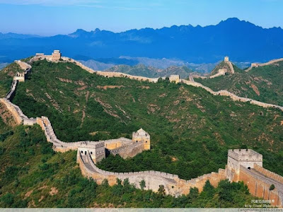
On July 21, 1969, the first man set foot on the moon. Neil A. Armstrong, commander of the Columbia spacecraft, was the one chosen by history for such a high honor. As Armstrong gazed at the Earth while resting on the Moon, he remarked that the only work of man visible from that distance was the meandering line of the Great Wall. Aerial View of a section of the Chinese Great Wall The Great Wall or the Great Wall of China is the name we Westerners give to the defensive system erected to prevent barbarian invasions during the Middle Kingdom. The Chinese call it Wanliuhangcheng, which means "the wall of 10,000 li" (li is a measure equivalent to 500 m or 0.31 miles): 6,300 km on which 25,000 towers stand.

Historic Monuments of the City of Novgorod and Surroundings

Image
Novgorod was the first capital of Russia in the 9th century. Surrounded by churches and monasteries, it became a center of Orthodox spirituality, as well as a nucleus of the development and evolution of Russian architecture. Its medieval monuments and the 14th-century frescoes of Theophan the Greek illustrate the development of this architecture and its remarkable cultural creativity. The city of Novgorod, whose earliest records date back to the 10th century, is located on the ancient trade route between the Baltic and Scandinavian countries. The urban aristocracy that ruled the city-republic called to reign a prince of the Swedish Varega dynasty. This type of organization, close to that of the cities of the Hansa, with which Novgorod maintained close trade contacts, was possessed only by the city of Novgorod and the nearby city of Pskov.  Saint Sophia Cathedral in Novgorod, Russia

The City of St. Petersburg: "Venice of the North"

Image
The origin of St. Petersburg, the former Leningrad, dates back to the initiative of Tsar Peter the Great to open an outlet for trade with the West. The first stone was laid in 1703 and the result was the most European city in Russia and a fascinating display of sumptuous baroque and neoclassical palaces between the wide canals of the Neva River. The Neva River and St. Isaac's Cathedral in the background

Budapest: Capital of the Danube

Image
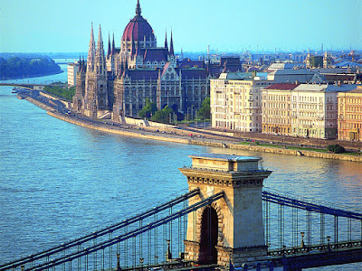
The river plays here, in the capital of Hungary, a stellar urbanistic role, delimiting two cities -Buda, on the right bank, and Pest, on the left- that until 1873 would not officially constitute the current urban complex of Budapest. The river Danube separates the old towns of Buda and Pest The Celtic and Roman footprint.  An important part of the present buildings of Budapest are seated on the ruins of an old Celtic fortification, which, appears in remote references with the name of Ak Ink. Its founders, in a time in which the heart of Europe was practically depopulated, chose this location for the numerous thermal sources that it counted on. In addition to the advantages provided by the Danube, Ak Ink counted on the rocky spur of Buda, a steep promontory ideal to protect itself from eventual attacks and where to place its burial mounds.

Top 10 Historical Landmarks and Monumental Sites in Germany (you probably haven't heard before)

Image
Germany is the fourth country in the world and fifth in Europe with the highest number of World Heritage Sites, behind Italy and Spain. While most people have heard of the "Brandenburg Gate", "Neuschwanstein Castle" or the "Berlin Wall Memorial" none of these monuments are on the list... So which sites make up the list of World Heritage Sites in Germany? Here we bring you a list of 10 sites of the total of 46 that are located throughout the territory of present-day Germany and that have been recognized by UNESCO for their historical heritage: 

City of Bamberg: One of Bavaria's Most Beautiful Cities

Image
The future Emperor Henry II, after his wedding night with Cunigunde of Luxembourg in 997, decided to give his beloved a gift that history will hardly forget: the city of Bamberg. The Counts of Babenberg owned a castle on a hill around which Bamberg had been developing since the end of the Carolingian era. The town became royal property in 906, before passing into the hands of the dukes of Bavaria. When Henry II, Duke of Bavaria, became Emperor of Germany in 1007, he made Bamberg a bishopric in order to turn it into a "Second Rome". In accordance with the rules of medieval town planning, the city was laid out in the shape of a cross, with the churches of St. Michael, St. Stephen, St. Gangolph, and St. James located at the four cardinal points.  The City of Bamberg

WĆ¼rzburg Residence and Gardens: One of Feudal Germany's Last Bright Spots

Image
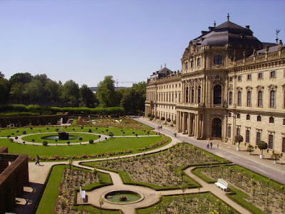
The late but splendid development of the German Baroque, which reached its peak during the first half of the 18th century, is due both to the genius of the architect Balthasar Neumann and to the patronage of the prince-bishops of Franconia. From the healthy collaboration between these two, the WĆ¼rzburg Residence, one of the last vestiges of feudal Germany, was born.  The WĆ¼rzburg Residence in Franconia (Germany) WĆ¼rzburg Palace and its park are one of the largest and most sumptuous urban residences in the German Baroque style. This former mansion of the prince-bishops of WĆ¼rzburg was designed in 1719 by Balthasar Neumann, court architect and baroque specialist, in collaboration with Maximilian von Welsch. The building is horseshoe-shaped, measuring 175 × 90 m, flanked by two large side buildings grouped around two courtyards. 

Old Town of Bern: City of Fountains

Image
Built on a rocky promontory closely embraced by the waters of the Aar, the old city of Bern preserves, in its plan and in its monuments, the trace of a long history that spans from its foundation in the 12th century to its last modifications in the 18th century, when urban expansion definitively abandoned the reduced space of its origins to extend westward the wide avenues and residential neighborhoods of the new city, today capital of the Swiss Confederation. Aerial view of the city of Bern (Old Town) The Aar is by no means a calm river. Fed by alpine glaciers, its waters tumultuously descend until they lose themselves in the lakes of the Swiss lowlands, tracing their course through landscapes as spectacular as the high rock on which old Bern sits. Unable to undermine it, the Aar forms around it a tight meander that is the best natural moat a city could dream of in the difficult medieval times. And the Bernese maintain a relationship of trust with their tutelary river that is striking

Historic Center of Warsaw: A Fairy Tale City

Image
The City of Warsaw (Old Town) Like so many other European cities, Warsaw owes its origin to a river, in this case, the Vistula. A small river port and a ford over which a bridge was soon built were the elements around which the first population center arose in the Middle Ages. Excavations within the present urban perimeter have revealed as many as three earlier settlements. The oldest, Stare BrĆ³dno, flourished during the 10th and 11th centuries, but was destroyed in the harsh feudal struggles of the time. It was replaced by the Kamion enclave, which existed as early as 1065, and this in turn by the Jazdow enclave, the oldest records of which date back to 1262. Some decades later, it was decided to move Jazdow to a site offering better defensive possibilities. A river terrace was chosen on the left bank of the Vistula, about 3 km north of Jazdow, on which there was a small village called Warszawa, exactly where the Stare Miasto, the old town of Warsaw, is situated today.

Mill Network at Kinderdijk-Elshout: The Most Iconic Landmark of The Netherlands

Image
Mill Network at Kinderdijk-Elshout was declared World Heritage Site in 1997 The contribution of the Dutch people to water drainage techniques is enormous, as attested by the extraordinary installations in the Kinderdijk-Elshout region where all the typical elements of this technology can be found: dikes, ponds, pumping stations, administrative documents, as well as a set of impeccably preserved mills. The Kinderdijk-Elshout network of mills is located in the northwest corner of the Alblasserwaard, bounded by the Lek, Merwerde, and Noord rivers. These mills drained the inner districts of Overwaard and Nederwaard until their closure in 1950. The 19 mills that make up this group are in good working order. In addition to these wooden and brick mills, the locks, the houses of the Assembly of the Water and Polders Administration (Wateringue) and the pumping stations have been declared World Heritage Sites.

Tower of London: A Symbol of English Strength

Image
Used over the centuries as barracks, royal residence, court, and prison, the Tower of London has played a leading role in the history of England since its founding in the eleventh century, becoming not only one of the most emblematic buildings of the city of the Thames, but a true symbol of the permanence of the British monarchy, embodied in the crown jewels that guard its mighty walls. The Tower of London

Stonehenge, Avebury and Associated Sites: Britannia's Prehistoric Wonder

Image
To speak of Stonehenge is to speak of a myth as universal as ancient. It would seem that it has always been there, ever since man learned to look around him, and over the centuries the mystery of its origins has given rise to the most diverse interpretations, from magic to science fiction. The existence of many other similar monuments in the region shows, however, that it is not an isolated work, but the mature fruit of a culture, or rather a succession of cultures, that flourished in western Europe before the dawn of history. Stonehenge in Wiltshire (UK) as of today

The City of Bath: The English Spa City

Image
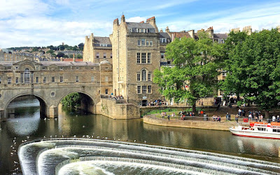
The ancient Roman city of Aquae Sulis has been an important spa center for centuries, thanks to its thermal springs. Alongside the Roman baths, excavated over the last 100 years, the city preserves an exceptional collection of neoclassical buildings dating from its heyday in the eighteenth century, in which the influence of the Italian Renaissance, in particular the great architect Andrea Palladio, is evident. River Avon In The City of Bath A British tradition attributed the foundation of Bath to Bladud, father of King Lear, who was cured of his leprosy by the waters of the place around 860 B.C. Without discarding the legend, there is no reliable proof of the existence of the city before the first century A.D. It is supposed that it was the Romans, following the conquest of Britain in 43 A.D., who discovered that there was a source of thermal waters by the river Avon. Their fondness for baths and their religious eclecticism led them to build a thermal complex and a temple dedicated to

The Drottningholm Palace: The Residence of The Swedish Royal Family

Image
In the vicinity of Stockholm, the magnificent Drottningholm Palace, with its various pavilions and gardens, forms a unique ensemble of beautiful grandeur in Sweden. Among its pavilions are considered of universal interest the Palace Theater, a true baroque stage still in use, and the Chinese Pavilion, wherewith great imagination the oriental inspiration is combined with the rococo. Drottningholm Palace was originally a royal residence and since 1982 has been the home of the Swedish Royal Family. Originally, the main body was connected to the corner pavilions by single-story wings; but in the mid-18th century a height was added and the palace acquired its present appearance. The interiors were decorated from 1670 to the end of the 19th century and are considered the most important in Sweden in their respective styles.

The Grand Place in Brussels, Belgium: A Historic Landmark

Image
When the Grand Place of the capital of Belgium was destroyed in 1695 by French artillery, the bourgeois of Brussels, proud of this commercial nerve center, instead of rebuilding it in a contemporary style, preferred to rebuild it in its former state and styles. It is interesting to note that it is one of the few main squares of a European city that does not house any church or other place of worship, which reaffirms its administrative and mercantile function. The Town Hall, which preserves its Gothic and 18th-century components intact and well visible, occupies most of the south side of the large square and consists of a group of buildings that are organized around an inner rectangular courtyard. Although it remained standing despite the bombardment of 1695, the building was restored immediately afterward, undergoing further modification in the 19th century.